Specify Digi Axess map display style
A set of Digi Axess map imagery options displays on the map page in the upper right corner by default. You can choose the imagery option that provides the level of detail you need.
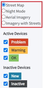
| Option | Description |
|---|---|
| Street Map | A flat street map without aerial imagery. This is the default. |
|
Night Mode |
A flat street map without aerial imagery in night (dark) mode. |
| Aerial Imagery | A high resolution satellite aerial image. |
| Imagery with Streets | A high resolution hybrid aerial image with street names superimposed. |
 PDF
PDF


